Catchment Area Planning & Hazard Mapping
Delivering Planning through Evidence-Based Approach
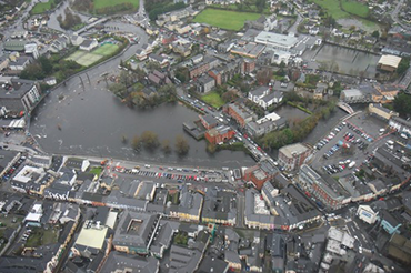
Catchment area planning is the recognition, assessment and management of flood risk at the river basin/catchment scale and is typically undertaken by government agencies, local councils and other authorities. Assessment at the catchment scale takes a holistic approach, applying mitigation measures that address and reduce flood risk on a broader scale. Where “broad reach” measures are not possible, local area flood relief schemes can be implemented. The Flood Directive (2007/60/EC), aims to protect vulnerable infrastructure but must be read in conjunction with the Water Framework Directive (2000/60/EC), which imposes a duty on member states to protect water quality. This is achieved by maintaining flood plains and restoring river basins. These aims have been integrated into planning guidelines, and now, most national agencies in Europe typically undertake national level catchment-based flood risk assessment. In Ireland, Ayesa work on behalf of the Office of Public Works (OPW) to provide hazard mapping services and modelling, an essential part of Ireland’s national Catchment Flood Risk Assessment and Management (CFRAM) study.
Catchment Area Planning uses an evidence-based approach for schemes informed by catchment risk assessments which detail:
- Historical flood events
- Rainfall records
- High-resolution floodplain surveys
- Detailed channel/structure surveys of selected rivers.
Our hydraulic models identify flood hazards (from river, sea, groundwater and rainfall) and flood risk (the resultant impact on people, the economy and the environment). We have delivered multiple flood relief schemes in towns and villages across Ireland to meet the needs of the local area and county development plans including:
- Arklow Flood Relief Scheme
- Bandon Flood Relief Scheme
- Borrisokane flood surface water drainage
- Clontarf Flood Relief Scheme
- Ennis Flood Relief Scheme
- Glen Passage West Flood Defence Scheme
- Howth Flood Relief Scheme
- River Dargle Flood Relief Scheme
- River Barrow Flood Relief
Recently we have been appointed to deliver solutions for Buncrana, Ballybofey and Stranorlar, and Ramelton in County Donegal.
Our value-based flooding solutions throughout the catchment are aligned with national policy and the natural ecosystems including:
- Walkovers/surveys to identify opportunities and benefits
- Stakeholder engagement and consulting and communication across a wide range of audiences
- Stakeholder research and surveys
- Detailed modelling and options assessments
Expertise In-Depth:
• Aerial /Lidar/ DTM surveys
• Area Planning
• Catchment area modelling
• Coastal modelling
• Contract administration
• Design of flood defence systems
• Early flood warning systems
• Ecological environmental risk mapping
• Environmental Impact (EI) & Appropriate Assessments (AA)
• Feasibility studies
• FCERM (Flood and Coastal Erosion Risk Management)
• Flood defence condition surveys
• Flood early warning systems
• Flood estimation
• Flood extent and hazard mapping
• Flood Relief Schemes (FRS)
• Flood resilience planning
• Flood Risk Assessment (FRA)
• Flood risk assessments & appraisal
• Flood risk management plans
• Flood risk management plans
• Flood risk/hazard mapping
• Funding submissions
• Ground Investigations and Surveys
• Hydraulic Modelling
• Hydrodynamic modelling & assessment
• Hydrological studies
• Natural flood risk management measures
• Pumping station assessment and development
• River modelling
• PSDP
• Stakeholder Engagement and Management
• Surface water modelling
• Topographical & bathymetric survey management


.png)


